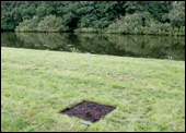
As someone who lives in a major metropolitan city and travels constantly, Google’s “Maps” and “Earth” applications are an essential necessity for finding my way through these urban landscapes. Whether it’s to meet a friend for coffee in a location I’m not familiar with or to discover the shortest route between two distinct locations, my life has become a lot easier since I’ve had access to both the web-based and mobile versions of these mapping systems. Subverting this paradigm of using these systems as utilities by hacking the virtual and real representations of Google Earth (as many artists have done before him), Dutch artist Helmut Smits follows in this continuum with “Dead Pixel in Google Earth“. The project is a physical landscaping alteration that burns an 82 cm x 82 cm size square in a field of grass, which measures the equivalent of one pixel of data at an altitude of 1 km when seen with Google Earth. This “missing pixel” is an interesting way of placing emphasis on the seemingly immaterial nature of digitized information, such as the sattellite photography used to populate the data sphere of Google Earth. The virtual equivalent of this project might be to remove a single pixel from the Neural’s homepage just to see if anyone notices the deletion. But this would never happen of course.
Jonah Brucker-Cohen