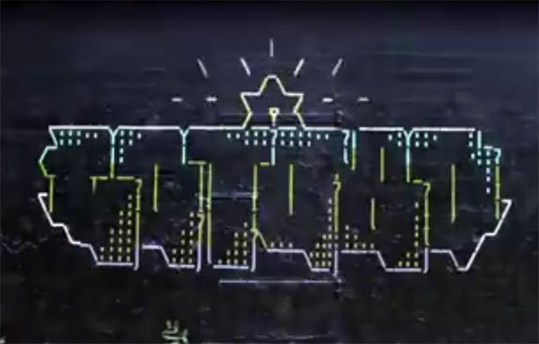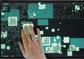
The project of Richard Vijgen Deleted City is an interactive data visualization of the myriad of data hosted on the free web hosting Geocities, that was very popular at the dawn of the commercial web. The city was the successful metaphor that characterized this site: the users could easily create their own Web pages and click on the “city” in which they preferred to live based on the type of content offered. For example, “Wallstreet” was the subject area of finance and business and “Vienna” the community of classical music lovers. The translation of the city into a digital image was a very intuitive concept at that time (1995), when the Internet was still quite difficult and unfamiliar terrain for non-specialist users. The symbolic accessibility of the “urban” metaphor combined with the free and simple use of the service caused the exponential growth of Geocities: by June 1997 it had become the fifth most popular site on the web. The acquisition by Yahoo in 1999 coincided with a blatantly commercial turning point in the management. This fact, together with the pressing emergence of the first social networks like MySpace, led many users to gradually abandon this service. This slow decline ended in 2009 with the final closure of the site by Yahoo, leaving all the Geocities archives offline and transforming the busy digital city into a sort of buried archaeological site. The interactive work “Deleted City” metaphorically carries out the appropriate excavations, resulting in a sort of “digital Pompeii” (as the author defines it). In fact, like the intact remains of the ancient city near Naples, the artist here crystallizes the last moments of the site just before its abandonment. The data required to display Geocities as a map were obtained from the backup made by “Team Archive” just before its switch-off. The design of the installation software is functional and clear: against a dark blue background a number of light blue square forms identify the cities and the neighborhoods, changing transparency in line with the density of the population. The results are reminiscent of classic X-rays but also of some aerial photos of hidden archaeological sites, which make visible the (squared) plots of ancient houses, through the absence or presence of grass on the ground (crop marks). Surfing this special map using the touch screen allows a full immersion in a “primitive” mode of social expression through the web. As privileged observers of this huge digital archaeological site, we can glimpse bits and pixels of what Olia Lialina defined as “digital folklore”, but above all we have the opportunity to observe an overall view, impossible to see in the complexities of an unlimited data back up.
Chiara Ciociola