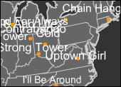
One of the most fascinating challenges pushed by the gathering of huge amount of digital data is to find effective solutions of visualization. From green letters on a black background in the first terminals we’ve come a long way, so the current mapping software features make that early technologies almost belonging to a distant geological age. Amongst the most popular experiments, those who tries to establish a relationship between the source and its geographical position. It seems that we are lost in the universe of digital (or digitized) information and so we feel the need of recontextualizing ourselves in the real world. This need certainly underlies Yesnation, a Flash application developed by Yes.net. On a U.S. map (with states borders) in the background, the aired tune’s titles by the vast radio stations networks pop up in real time. The titles appear, related to the particular place where the radio station is placed (on the map is a red dot), and then suddenly disappear without a trace. It could seem banal to underline that in California there are lots of titles in Spanish, and in Montana the multi-culturalism is still a utopia. But in the end the most interesting element of Yesnation is to give us a snapshot of U.S. radio universe. An ephemeral snapshot, indeed, because it is intended to disappear at once, making space for a new one. But this work is qualified by a density of meanings that only the transitory nature of instants is able to transmit.
Vito Campanelli